
Walk an Andover Street
A useful Andover street-by-street search begins in the Anoka County Property Search GIS Mapping Application. Enter the Andover house number and street name without the city or punctuation. If that fails, try the number, a partial street name, or the full directional suffix. Click the Andover parcel, record its PIN and legal or plat context, then open the linked tax record. GIS is the Andover map and address layer; Property Access is the Andover assessment-card layer. Keeping the Andover PIN beside the Andover address makes later deed and map work more reliable when a street description changes.
- Normalize the Andover address. Keep NW, NE, SW, or SE, the Andover road type, unit, rural-route wording, and any Grow Township or Round Lake Township name found in older papers.
- Search the county GIS by Andover address or PIN. Record the Andover parcel boundary, PIN, plat, and property address before moving to a people-related record.
- Open Anoka County Property Access for the Andover owner field, owner mailing address, tax information, homestead indicator, and legal description.
- For a dated Andover ownership question, use the recorder’s Grantor/Grantee route or the public research terminal. Voter information is controlled by statute and is not an unrestricted online street roster.
- For an older Andover household lead, compare the property trail with the incomplete Andover telephone-directory holdings and census or newspaper evidence for the same period.
Each Andover stop answers a narrower question. An Andover parcel card supports an ownership finding; an Andover deed supplies a conveyance trail; an Andover historical telephone listing may identify a subscriber at a dated address. None alone proves every person who lived there.
Note: When several parcels match, the PIN and legal description are better tie-breakers than an abbreviated street label.
Andover Street Directory Search Inputs
The county’s GIS search tools are unusually useful for an Andover street directory because they accept both address and parcel forms. The official guidance supports a full or partial street query, an intersection written as street&street, and PINs with or without hyphens. Property Access supports a combined search with owner name, address, parcel/PIN, tax-year, and report choices, although the public portal displayed a maintenance notice during the research inspection. Use GIS first when an address is uncertain, then use the property card as the record detail.
| County search field | Input type | Required | Observed format or result |
|---|---|---|---|
| Andover GIS category | Dropdown | Yes | All, address, parcel ID, multi-units, plat boundaries, half sections, schools, or public buildings. |
| Andover address query | Text | No | Use an Andover house number, full or partial street name, with no city or punctuation. |
| Andover PIN / parcel ID | Text | No | County GIS accepts hyphenated or unhyphenated Andover parcel identifiers. |
| Andover intersection | Text tool | No | Use an Andover format such as Main&3rd, then select a result to zoom. |
| Andover property owner | Text / search mode | No | Supported through the Property Access combined workflow; wildcard rules were not located. |
| Andover tax-year report | Selector | No | Basic current reports and multi-year reports for 2020 to present are documented. |
Do not turn a partial match into an Andover household match. The Andover GIS category, PIN, and parcel outline help separate like-named roads, multi-unit addresses, and close Andover street segments before a record is attributed to an Andover address.
An Andover Parcel Result
The Andover property card distinguishes the Andover property or situs address from the owner mailing address. It can also show tax year, class, property-use code, acreage, lot data, districts, homestead, legal description, current owner, ownership percentage, and links to transfers, values, tax summaries, and assessments. Matching Andover mailing and situs addresses can be a useful ownership clue, especially alongside a homestead indicator. A different Andover mailing address can simply reflect correspondence for a nonresident owner, trust, or company. Neither value names every occupant.
The Property Access sample parcel card shows the kinds of owner, situs, tax, and legal-description fields available in the system. It is a county reference example, not an Andover household record.
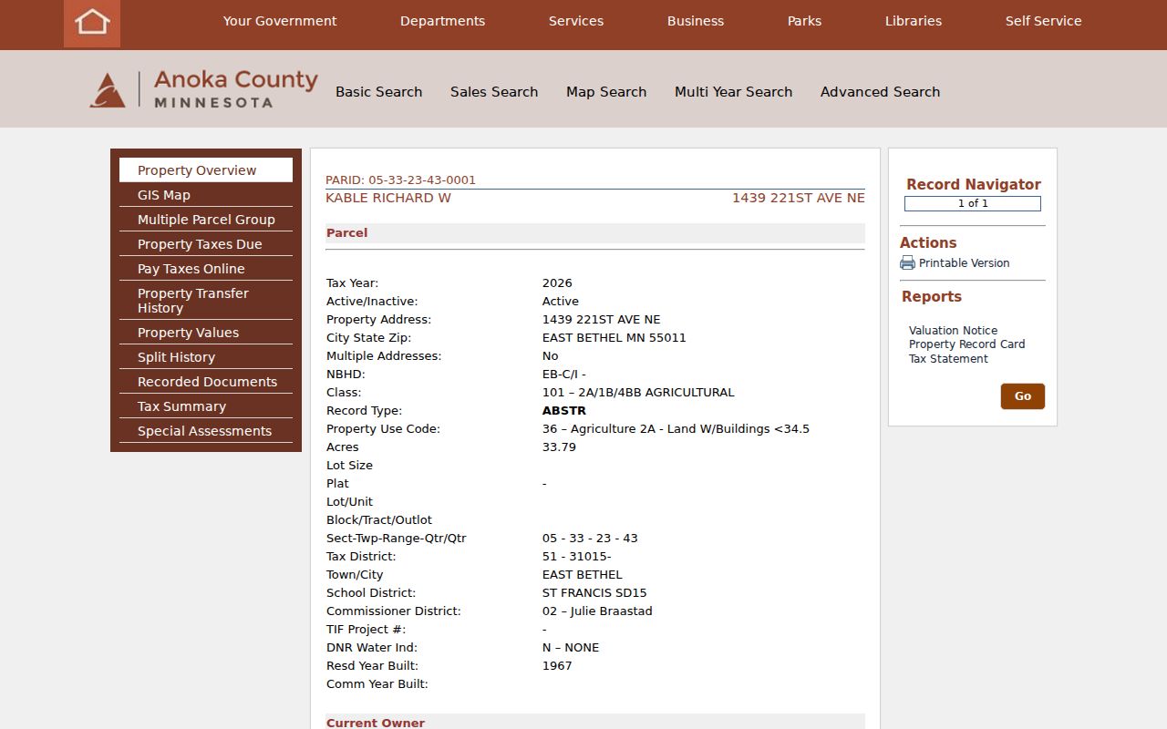
The card illustrates why an Andover street directory should treat a parcel result as a documented property record, then corroborate any time or household question with the appropriate dated source.
- Andover parcel or PIN
- An Andover county parcel identifier ties a mapped property to tax and land records more reliably than a street name alone.
- Andover situs address
- The physical Andover property address used on the tax record. It is different from an owner’s mailing address when tax correspondence goes elsewhere.
- Andover plat
- An Andover recorded subdivision map can identify lot, block, or parent-tract context for a parcel.
- Criss-cross directory
- An address-first directory format. No separate official Andover criss-cross title or verified street section was located, so it should not be assumed for every telephone volume.
Andover Street Records Compared
Address-keyed sources work best as a chain. The county GIS fixes a parcel in space. Property Access adds ownership and tax fields. The recorder follows the legal parties and description, while historic directories and city files may add a dated address clue. The coverage below separates what each Andover street record actually establishes from what it leaves open.
| Address record | Custodian | Evidence supplied | Access route |
|---|---|---|---|
| Andover property card | Anoka Property Records & Taxation | Andover owner, owner mailing address, situs, values, homestead, and legal description | Free Andover Property Access, with current and multi-year reports. |
| Andover GIS parcel | Anoka County GIS | Andover PIN, parcel geometry, plats, aerials, districts, and nearby parcels | Free Andover web map with map tools and layers. |
| Andover recorded deed | Recorder / Registrar of Titles | Andover grantor, grantee, recording date, legal description, and conveyance | Andover subscription route, Room 119 terminal, and copy or image options. |
| Andover permit or city case | Andover Building Department or City Clerk | Andover address-keyed application, inspection, or public-case evidence | Baseline application route or a Minnesota Government Data Practices Act request; public history coverage was not located. |
| Andover telephone directory | Minnesota Historical Society and ACHS | Dated Andover subscriber, telephone number, and address where listed | On-site holdings and finding aid; Andover years are incomplete. |
| Andover public voter list | County auditor / Secretary of State | Lawfully requested Andover public-list fields | Controlled Andover request and certification, not an Internet street search. |
The Andover field order matters. An Andover tax card’s owner line is not evidence that a named person occupied the address. An Andover telephone listing is a subscriber clue, not proof that every household member lived there. Keep the Andover record date and source with every note.
Andover Deeds Behind Addresses
Old deeds do not reliably use the modern street address. After the PIN and legal description are known, search the current owner as a grantee in the recorder’s index, find the purchase deed, and record the document number or book and page, date, grantor, grantee, document type, and legal description. The seller on that purchase deed becomes the next grantee search in the earlier period. Use the lot, block, plat, or section description rather than relying on the street alone.
Anoka County Recorded Document Access documents a monthly subscription for Grantor/Grantee searching and access to recorded plats or surveys. The county also provides public research terminals and tract information in Room 119 at Property Records & Taxation, Monday through Friday, 8:00 to 4:30. The county has not published an online deed-index start year on the inspected pages, so an early break in the online trail calls for the research room, deed books, microfilm, or staff contact rather than a guessed cutoff.
Note: The recorder preserves land documents but does not give legal advice or interpret a title chain.
Andover Street Directory Years
For a past address, the verified local run is an Anoka County telephone-directory collection, not a continuous Polk-style city-directory series. The Minnesota Historical Society finding aid lists Andover holdings beginning in 1978, with a mix of print, microfiche, and Yellow Pages through 2005, plus a 2011 to 2012 Yellow Pages volume. The pattern has gaps, and some years are Yellow Pages only. A missing entry may reflect the collection, a subscriber choice, a new move, or an absent phone service.
White pages are alphabetical residential and business listings that can include a phone number and street address. The research did not verify a local reverse-directory title or a street-by-street section for the Andover volumes. Browse an address section only if the particular physical volume has one. For older records, use Grow Township or Round Lake Township terms with plats, newspapers, census material, and deeds rather than assuming the modern city name appears.
Historical telephone material belongs with the broader collection context on the Andover city directory page; use it here only to add a dated street clue to a parcel trail.
Andover Street Voter Limits
Minnesota’s Check Registration tool is designed for a voter to check their own status and precinct. It is not a public browser for every address on an Andover street. The state’s public information list has narrower lawful access: an eligible requester supplies identification and a written certification, and the information may be used only for elections, political activities, or law enforcement under Minn. Stat. §201.091.
The restriction is practical as well as legal. The statute bars publication in an Internet-searchable database and bars sale, lending, or surrender of the list. Safe at Home participants and people with a safety withholding can be absent from public-facing information. A public-list result should never be copied into an address directory or used to fill a gap left by parcel records.
Andover Permit Address Trails
Permits can put a date on construction or inspection activity at an address. The Andover Building Department reviews applications and inspections, and its public materials point to applications and the Baseline submission and payment route. The research did not locate a public permit-history search interface or a verified coverage start year. That means an address history may require a request through the City Clerk and the Minnesota Government Data Practices Act rather than a claimed online search.
Use a permit as event evidence, not as a resident roll. Public files may name an applicant or contractor, and protected or private fields may be redacted. Pair the document date with the parcel PIN, legal description, and any deed or newspaper record so a similar address does not become a false match.
Andover Street Map Layers
County GIS can show more than parcel outlines. Its tools include current and historical aerials, plat and half-section views, selectable layers, a Near Me tool with adjustable radius, measurements, intersection search, and mailing-label output. A line, point, or polygon selection can produce owner-address or physical-address labels as CSV or PDF. Those exports remain parcel-based, so choose the address type deliberately and do not treat physical-address labels as a roster of people.
The Andover city GIS resources add city limits, MUSA, preserves, parks, waterbodies, and section lines. School, watershed, commissioner, and other district fields can explain why adjoining parcels have different administrative contexts. ZIP labels and an Andover postal line do not settle municipal jurisdiction; the parcel map and city-limit layer do.
Andover Street Records By Numbers
Anoka County reports that Property Records & Taxation maintains more than 140,000 property records and processes about 75,000 real-estate documents each year. Those figures help explain why a parcel-first method is more dependable than reading a street name as one record unit. A street can cross plats, districts, and property types, while each parcel has its own PIN and legal description.
Volume also makes careful scope important. The GIS mailing-label and Near Me tools are designed around selected parcels and map geography. They do not transform county property data into a complete list of people who reside along an Andover road.
Andover Street Research Fallbacks
When an online result is missing or Property Access is unavailable, shift channels instead of substituting a weak source. Property Records & Taxation has a public research area in Room 119, 2100 3rd Avenue, Anoka, open Monday through Friday from 8:00 to 4:30. The office lists 763-323-5400 and proptax@anokacountymn.gov for property-record questions; recorded-document subscription questions use 763-324-1157. The research room supplies real-estate and tract information beyond the free property card.
For older neighborhood context, the Anoka County History Center holds maps, newspapers, census material, and selected civil or church records. A request for government data can also be routed under Minnesota’s Chapter 13 procedures when the record is public but not posted. Ask for the specific address, PIN, date range, and record category. That description gives the custodian a workable request and preserves the boundary between public documents and private data.
Note: Keep copies of requested record numbers, response dates, fees, and the custodian’s stated access limit.
Andover Street Directory Limits
An Andover street directory cannot show every person at an address. County parcel records identify owners and mailing lines, not all occupants or household members. Utility customers, delivery data, and motor-vehicle addresses are not public household directories. Protected voters, Safe at Home participants, and other protected records may also be withheld. An empty or different result can reflect the scope of the source rather than a conclusion about a person.
Source checks matter, too. A mailer offering an expensive deed copy may imitate an official notice. Verify document and copy questions with the county recorder, whose published fee schedule lists an attested copy at $2 and a certified document copy at $10, and confirm current fees before ordering.